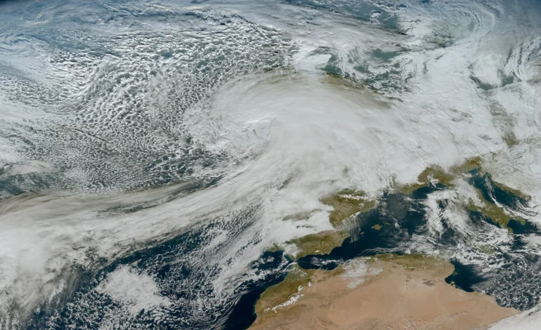
Storm Chandra is set to sweep across parts of the UK this week, bringing a fresh mix of heavy rain, snow on higher ground and the renewed risk of flooding, as forecasters warn of difficult conditions for travel and local communities.
The storm was named on Monday morning after meteorologists assessed that its impacts were likely to meet warning thresholds. Northern England, particularly higher ground across the Pennines, is expected to see snowfall, while large areas of England, Wales and Northern Ireland face prolonged spells of rain falling on already saturated ground.
UK News — More from EyeOnLondon
Three recent stories offering context, insight, and a wider view of events shaping the UK.
Major wind farm project to include the UK
What the proposed development involves, why the UK has been included, and what it could mean for energy policy.
Read the storyMore UK News
Amelia AI meme sparks online debate
How a single image spread, what it reveals about artificial intelligence, and why the reaction matters.
Read the storyMore UK News
UFC interim lightweight title bout set for Pimblett and Gaethje
What is at stake, how the matchup came together, and why it matters for the division.
Read the storyMore UK News
Several centimetres of snow are forecast above around 400 metres, with deeper accumulations possible at higher elevations. In lower-lying areas, rainfall totals of 20 to 30 millimetres are expected widely, with some places receiving closer to 50 millimetres over a short period.
A spokesperson said conditions could become hazardous quickly. “Flooding and travel disruption is likely in places, with significant snow across higher ground in some northern areas,” they said, urging people to monitor updates closely as the system moves through.
Flooding risk downstream
One concern for emergency planners is what happens after the rain and snow ease. Water moving through river catchments later in the week could increase the risk of flooding downstream, even once skies begin to clear. This delayed impact has become a familiar pattern following intense winter rainfall.
Drivers are being warned to take extra care, particularly on rural roads where surface water and ice may form overnight. Rail passengers are also being advised to check services before travelling, as snow and waterlogged tracks may lead to delays.
Although wind warnings are not currently in force, the storm follows several days of unsettled weather that have already brought strong gusts and large waves to coastal areas. Further disruption along exposed coastlines cannot be ruled out.
Advice for residents
People living in flood-prone areas are encouraged to stay alert to local conditions, avoid unnecessary journeys during the worst of the weather, and prepare properties where needed. Up-to-date flood guidance and live risk mapping can be checked via this official service.
Forecasters have stressed that warnings may be updated at short notice as Storm Chandra approaches and evolves.
For more independent coverage of weather events affecting London and the wider UK, follow EyeOnLondon. We welcome your experiences and observations in the comments.
Follow us on:
Subscribe to our YouTube channel for the latest videos and updates!
We value your thoughts! Share your feedback and help us make EyeOnLondon even better!